Saturday 10 July 2010

Meall Chuaich. Drumochter, 10th July 2010

Day three in the Verdes House saw me waking up with aching legs, sore feet and a distinct desire to get home.

Weather forecast predicted that this was going to be the worst day of the three, with severe gales, thunder and lightning and of course, more than a fair share of rain.

I had decided the night before that I would stick my head out my velux window and make a decision in the morning as to whether I should go or stay. I hadn’t slept very well and my feet were aching from the long walk of day one compounded with a wet feet road walk on day two.

However, just in case the conditions were favourable, I had set my alarm for an early dart.

I tentatively pulled my curtains back expecting to see low rain cloud through the rain drops on the velux, but was surprised to find that there was little wind, good visibility and whilst overcast, the cloud was well above the tops.

This was too good to miss.

I flung all extraneous kit into my duffle bags and packed for the walk. My normal boots were completely drenched from the day before and the ‘peat bog massacre’ so I had to revert to my old leather 4 season boots.

I took a couple of bites of my bacon butty and headed off, anxious to get as far up the seventh Munro of the week, Meall Chuaich (hill of the bowl, 951m) before the adverse weather arrived, as arrive it no doubt would.

I parked up at Chuaich and got my boots on, acutely aware that I was leaving my laptop in the car, in a lay-by and reminded of my idiocy by the police notice ‘do not leave valuables in your car’ at the verge.

Even though I was in heavy boots and my feet were aching, I set off at a good pace, conscious of the weather timing and my unattended laptop. The walk along the track was painful and I was looking forward to getting onto the hill proper, where they would take less of a pounding.

Three miles later, I found myself at the bothy looking up at a summit that was rapidly disappearing under a layer of cloud. This provided some urgency to my endeavour, as not even Ginger buggers about on summits in lightning.

I pushed hard on the ascent and got to the top 2hrs 20 mins after leaving the car, just as the wind started to pick up and the cloud crept in. I didn’t delay and headed off again cringing at the view of the long road walk back to the car.


I met a few people coming up as I was going down and they seemed unperturbed at the changing conditions above us; perhaps they knew something I didn’t, so I just kept my head down and arse up and descended as quickly as possible. By the time I arrived at the bottom, the summit was hidden in thick cloud and fine rain was starting to fall.


By now my feet were really aching; four season boots and roads do not make good bedfellows. Still it looked like the forecast was going to be right for once so I just horsed on and was back at the car in 4 hrs 20. As soon as I arrived, the heavens opened with a heavy down pour that stayed with me all the way down the pass.


I had arrived three days earlier in heavy rain and departed under the same conditions, but had had a great time.

The Drumochter Munros are very forgiving and look ideal for some winter play, without the need to venture into the Cairngorms.

I’ll definitely be back.

Friday 9 July 2010

A'Bhuidheanach Beag, Carn na Caim. Drumochter, 9th July 2010

Day two of the Drumochter adventure started, naturally enough, with some fantastic bacon butties and a coffee. The Balsporran Cottages are not only an ideal base for the surrounding Munros but a lovely venue for walking, fishing or any other highland pursuit.

Weather forecast wise, day two was allegedly the best day of the three and I planned to do the two Munros on the other side of the road, A'Bhuidheanach Beag (little yellow hill, 936m) and Carn na Caim (cairn of the curve, 941m).

As usual, the forecast was only slightly out and none of the surrounding hills were visible under the low cloud and torrential rain that had been hitting us since early morning.

So much for the best of the three days!

However, in a superb reversal of a typical Verdes plan, I merely switched activities around and decided to go to Aviemore on a therapy session before tackling the aforementioned Munros. 30 minutes later I was in the Cairngorms activity capital and flicking through waterproofs, books and other outdoor gear. The weather in Aviemore was ok; fine drizzle and light winds.

Maybe things were looking up.

I raced back down the pass to Balsporran to get started but the closer I got the lower the cloud and the heavier the rain. You could see it as you drove down the pass; a huge blanket of grey suspended over the Drumochter Munros.


I parked up and went in to get changed and in the 10m dash from car to building managed to get soaked through.

I got into all my gear and set off with the rain bouncing off road, wondering why I was bothering. The wind was in my face all the way to the spot height above the A9 and I had been advised by Phil from the B+B to pause and have a look down onto the road from this point – 'spectacular' he called it.


I couldn't not do it, as he would definitely ask at dinner, so with the wind gusting at my back and propelling me forward to the precipice, I struggled to keep on the right side of oblivion, hanging well back from the edge.


But once there – what a view down onto the passing vehicles.


Nice on a sunny day, bloody frightening with the wind threatening to push me over the sheer drop.

Photo taken, I again had to revert to compass and pacing to negotiate the swamp that took me to the ridgeline. I followed this up in very low visibility to the next spot height, where I made a turn that took me to the summit. Again, a fence line acted as a catching feature and led me to the summit.


At the top I realised just how cold it was. The wind was gusting strongly and the rain hadn’t let up since the cottages. To save a bit of time, I took a bearing on my next point and took the direct Verdes route, straight down the hillside between two ‘streams’. Whilst the navigation was unerring, the endpoint did turn out to be a 150m wide quagmire of peat bog and it took me 45 mins to pick a way across, inadvertently coming off bearing as I did so.

If ever the 'Battle of the Somme Reenactment Society' need a venue, this place is it.


Nightmare. Ankle deep in goo, 10m visibility and the bloody wind and rain still wouldn’t let up. I can see why people panic in this kind of crap. It’s thoroughly unpleasant. Still, the path couldn’t be far away and with a bit of common sense and my trusty walking poles, I once again found the track.

By this time I was cold but feeling quite strong, so I put on a bit of a Ginger pace to get things moving again. I was soon at the quarry and on my way to the second summit of the day which, all of a sudden, I could see.


Was the cloud actually lifting?

Indeed it was, although it was still only a few metres above the summits. This provided a rather bizarre vista with sunshine being visible a few miles away, under the thick cap of grey cloud above my location.

As I approached the second summit, the cloud cleared further and by the time I had returned to the quarry the sun had come out, the wind had dropped and opportunities for taking photos were aplenty.

Typical. The bloody forecast was only about 12 hours late.

Worse was to come. Now I could see where the track was actually taking me and as I descended, the path was taking me further and further away from the cottages, leaving me with a monster road walk to get back in by now what was a baking sun.


With sunburnt face I arrived back at the cottages where some other visitors had arrived. As I explained about the crap weather earlier in the day, I could sense they thought I was lying, so I quickly shut up and went for a shower.

A good day on the hill and definitely a Viking day to quote the bold Ginger.

If Viking means ‘bloody awful for the most part’

Thursday 8 July 2010

Sgnairneach Mhor, Beinn Udlamain, A'Mharconaich and Geal Charn. Drumochter, 8th July 2010


Many’s the time I have driven through the Drumochter Hills on my way up to the Cairngorms. In winter they carry a lot of snow and beguilingly look very tempting and due to this they have been on my ‘must do’ list for some time.


The Drumochter Munros are split either side of the A9 with four on the west side, two directly opposite on the east side and a further one about 3 miles up the road, again on the east side.


Ideal for a three day trip.


Staying at the Balsporran Cottages, it was my intention to tackle the first four anti clockwise, starting with Geal Charn (pale hill, 917m). However, the forecast for the three days was atrocious with gale force winds from the SW so I changed my plans to a clockwise direction in order to have some wind at my back for the return leg. The circuit was around 16 miles and completion time estimated at 8hrs.


Of course, you cannot be 45 miles from Grantown on Spey and not feel compelled to meet with ‘the man’. With nothing to do on the first evening but sit about or eat, I decided to head up to that guru of mountaineering, that doyenne of the outdoor world, that legend in his own lifetime, the one, the only, Malcolm Ginger Lee.


Thankfully the oracle was at home and after a couple of hours drinking his tea and boring him to death, I decided that my work was complete.

The next day was exactly as forecast. Awful. The wind was blowing a hoolie and the cloud was thick and low. As I marched down the A9 to the track I needed, I caught occasional glimpses of my goals for the day, lurking behind the clouds and other lesser hills.


Finding the track I followed it for a couple of miles, hood up and leaning into the wind trying to decide when to break from the path to find a way up the first, Sgnairneach Mhor (big stony hillside, 991m). As I stopped for a drink, right beside me on the path was a tiny cairn. Taking a chance, I decided to follow a route from this point up the hillside and lo and behold a stream/path led from here to up onto the summit. It was really boggy and not a path as we know it, but still better than heather bashing.


There were some good views momentarily from the summit, but I could see a really thick cloud bowling in from the south, estimating an arrival time of about two minutes. Getting to the next summit required a dogleg route to be taken so I hastily got the map out and worked out bearings and pacing as I figured visibility would disappear as the clag hit. As I was putting the map away I felt the first big drops hit my hood and as I turned the world just went grey and very wet. After two or three paces the trig point had almost disappeared and I was back in the surreal ‘hood up world’ of walking on a bearing for a set number of paces, desperately trying not to be distracted by the wind.


When the time arrived to take my next bearing to complete the dogleg, the cloud got thicker and the wind was on my left shoulder. The required number of paces taken, I stopped to establish my position. After a few minutes, the wind had blown a gap in the cloud and I found myself in exactly the right spot for the ascent to Beinn Udlamain (gloomy hill, 1011m). I had been trying to get to a spot that avoided losing too much height and thankfully had nailed it on the first attempt. Picking up the metal fence posts that mark the Inverness shire/Perthshire borderline, I wended my way to the summit, taking in both shires as I zigged and zagged upwards.


At the summit, I met a guy who was taking my original route and who had decided to pack it in because of the wind in his face. Nice to know I had made the right choice!


The walk over to A'Mharconaich (place of horses, 975m) was straightforward and at last the gale was at my back. The heavy rain had dispersed to the odd shower, but the temperature had fallen a few degrees too.


All day long there was a pair of RAF Tornados exercising in the area which could be heard but not seen. As I made my way along the ridgeline to the summit, I could hear them again and stopped to see if I could see them. As I looked left and right, trying to catch movement, I noticed two black specks coming right at me. They passed over me, one either side, and very, very close.


Similar to the special flypast Ginger had arranged when we were coming off InPin, only more personal.

Ten minutes later, I could see Balsporran Cottages from the summit and Geal Charn across the valley; still a long way to go.


Instead of following the path all the way back along the ridge and I decided to ‘go Verdes’ and cut the corner, heading off down the slopes to the start of Geal Charn’s ridgeline. This saved me about 20 minutes and it was a straightforward walk to the summit. I again elected to avoid reversing my route and therefore the track and chose instead to take the direct route back to the cottages.

I arrived back safe and sound in 7hrs 30 mins having only met three people all day.


An excellent walk and having seen the lie of the land, the best route to take is anti clockwise.

Saturday 3 July 2010

Cyfrwy Arete, 3rd July 2010

Today saw Rich S and Tim attempting the Cyfrwy Arete by The Table Direct, a 194m VDiff.
Across the road from the car park and weather permitting, you get your first look at the climb. Even from this distance it looks like a challenging proposition.

The walk in follows the Pony Track which is a well made, but steep route to the summit of Cadar Idris. After the last intake wall is passed we followed a less frequented path to Llyn y Gadar which is at the bottom of the climb. From a distance it looked as though this path would take us through a scree field but as we got closer it was apparent that our scale was somewhat out. The scree was in fact boulders ranging in size from house bricks to small cars and made progress slow.
We could see a couple of climbers just starting the route so we decided to pause and have a sandwich while we watched their progress.

After our refreshments we set off up the steep and very loose boulder field to reach the start of the climb.
As we arrived the party we had been watching had reached the start of the second pitch and were just setting off.
The first pitch of 9m is a grassy scramble so we didn’t bother getting the ropes out until the start of pitch 2. It took 5 pitches to cover the 90m or so to reach The Table, the large broken slab that is a prominent feature of the climb. The climbers in front of us were still tackling the next pitch so we stopped here to admire the views and take on some more fuel by way of crisps and sandwiches.
To continue from The Table you have to down climb into a gully and then climb back up a short pitch before reaching a pinnacle. I lowered Tim into the gully and kept him on belay until he was safe at the pinnacle, he then kept me on belay from the other side while I did the same route. With Tim suitably positioned I carried on passed him and led the next, most exposed and least protected pitch. Another 2 pitches and a long roped scramble along the ridge and we made the top! 194m in total!

The views over the coast were excellent and the walk down in late afternoon sun was fantastic.
Climbing in boots with all your gear on your back is a rewarding and excellent adventure.

Thursday 10 June 2010

Last of the Arrochar Alps – Beinn Bhuidhe, 7th June 2010


Having completed all the other ‘Arrochar alps’, the prospect of having to complete Beinn Bhuidhe has been a particular thorn in my side for a couple of years.

There are a few reasons for this.

First, it’s an outlier, insofar as it isn’t attached to any other peak, so it’s a long way to go for just one summit. Secondly, the start is so far from the car park that it is recommended that you cycle in. Thirdly, due to the shape of the mountain and the way that it catches the rain, it is renowned as a mud bath, particularly once you gain the corrie and make your way over to the ridge.


I read in one climber’s forum of a guy nearly losing a boot in shin high mud as he tried to pick his way across to the ridgeline slopes.


As I set off, the weather forecast was for thunder storms and torrential rain, so there would be plenty more mud then.


I arrived on Sunday night in Arrochar at the B+B and went for an evening walk. 8 minutes later, after meeting then outrunning the local midge squadron, I arrived back in need of bed and sleep. Sadly I hadn’t noticed that the owner had opened my window to air the room and the midge squadron had landed just before me.


In spite of the odd nibble, they were surprisingly quiet and I had a decent sleep and was up early to get breakfast.


I drove over to the top of Loch Fyne and parked up. The weather was ok; a bit over cast, no wind and quite warm.


Ideal for the midge population.


I hauled the bike out of the landy and got myself ready for the cycle in. I had decided to travel light no matter what the weather and with a glance at the map, set off for the 5 mile ride.


Pedalling a bike with rucksack on is a strange experience but eventually I arrived at the point where you leave your bike and walk the rest on foot. Securing the bike, I walked the next mile to the cottage that signifies the start of the route up to Beinn Bhuidhe.


There is a path of sorts and it meanders roughly up the course of the stream to a waterfall. There are a couple of hairy bits with really slippy rock and a 50ft drop into the river if you slip, but I was forewarned by the climbers forum and knew what to expect.


In the rain though….

On arriving at the waterfall, you can keep on the path, which takes you through the mudfest or, as I did, you can elect to cross the stream and make your way up some really steep slopes and sweep round behind the swamp.


As I clambered up some really steep and undulating ground, I patted myself on the back that at least I was avoiding the mud. The midges were in action, but I had taken the precaution in liberally covering myself in mozzie repellent. This anti insect layer came at the expense of not wearing sun cream as I wasn’t entirely sure what type of chemical reaction I would have caused by applying both.


Naturally, having made this decision, the sun came out to play and roasted me for the next 4 hours, whilst the midges kept their distance, flicking me the bird as they watched me fry.


I arrived at the right hand side of the corrie and had some good views of the mud I had avoided – except there was very little mud to speak of. Only slightly disheartened, I began to traverse back over, looking for a line to take me up the final steep slopes to the path I knew to be on the ridgeline.


A short slog later and I was on the ridge and on the path. Following this was easy enough and it took me right to the summit and into the biggest cloud of crane flies I have ever seen. There had been thousands of them on the way up but I didn’t realise they had colonised the summit cairn.


If you look closely enough, there’s even one in my summit photo.


I decided against reversing my route and elected to follow the path back down to the waterfall, crossing the mythical mud bath. There actually was some boggy stuff, but this was easily avoided and having summited in 4 hrs from the car, it only took 2 hrs 20 to get back.


Hindsight eh?


The cycle back was entertaining as the path was invaded by a herd of highland cattle each equipped with VERY long horns.


Beinn Bhuidhe was in the bag at last. I’d had a great day weatherwise and, with zero wind and no other human in sight for the best part of seven hours, one of the most tranquil days in the hills I have ever had.

From the top I could see the thunderstorms that had been forecast and it was as if they were keeping away for the day as I basked in my little oasis of sunshine. 15 minutes later as I was driving back home, the heavens opened and things were returned to normal.


Next challenge is Crianlarich range, but first the Drumochter hills and the last two up north are going to have a visit.


As always, you are welcome to come along.


Davie


Monday 17 May 2010

Ben Vorlich, Arrochar Alps. 8th May 2010

Last weekend saw Davie tackle the last of the Arrochar alps after a lull of nearly two years.

The last time I was up, Champo and I bagged Ben Vane on the other side of Loch Sloy from Ben Vorlich and the weather was really foul. The top of Ben Vorlich was hidden by the clag with only the super steep slopes showing beneath a heavy cloud base.

If Cameron McNeish's book is to be believed, 'there are no discernable paths on Ben Vorlich', and the walker should just pick a route and go for it.

I woke up to a fantastic sunny day and decided to get moving as quickly as possible - the hills were bound to be getting some traffic. I arrived in the Inveruglas car park at 8:15am and was on my way by 8:30am.


I opted to head towards the Loch Sloy dam and see if any particular route jumped out at me. It's a good walk in and there were opportunities aplenty to get the climb started - they were all bloody steep so no advantage really in delaying OR starting early. There was one stand point at the power station where Ben Vane and Ben Ime were in panorama so managed to get a good snap of this, with the power station in shot too....bugger.


About 200m from the dam I decided to head on up the hillside, heading for a space between two crags. As height was gained, the views were exceptional over to Ben Vane and memories of Champo and I flogging our way up through the heather to gain the summit came flooding back.


After about an hour of continuous flogging, I thought I heard voices over to my right and sure enough, about 300m away, there were some people taking a different route to the summit.

They looked to be making better progress and I put this down to the fact that I had had to circumnavigate some large craggy areas en route.

Ten minutes later, I rounded some boulders to find....A PATH...

McNeish you lying ba*sta*d.

The other party had been cruising up a reasonably well formed path as I had been on the steepest part of the hill (or so it felt). This path was an alpine superhighway (well not really) that led from the road in the valley floor right to the summit.

I don't like to see human effort unrewarded so, in a recognition of services rendered, I had no option but to use this path to gain the summit. 3 and a half hours after leaving the car, I was stood on the top, looking over to Ben Lomond, Loch Lomond and the Trossachs. There were plenty of distant Munros to be seen with many still snow capped.


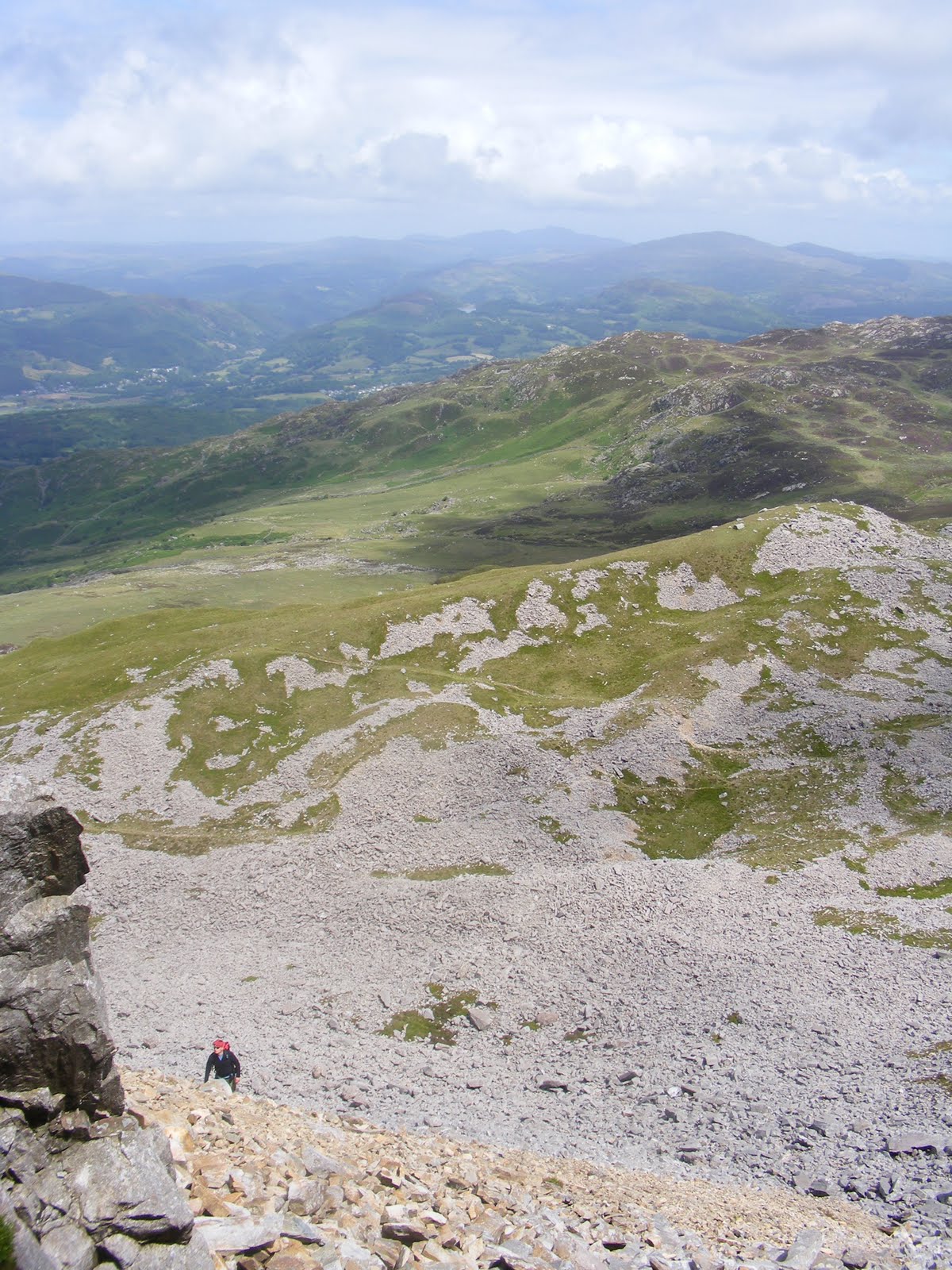
After a few minutes, I headed back via the superhighway and got myself back to the car in just under 6 hours. Even with the rudiments of a path, the descent was hellishly steep and it was worth while taking a bit of extra time to get down safely.

All in all a nice raid to one of my favourite places in Scotland.


Not long to my next trip...so keep watching your emails...


Davie

Thursday 8 April 2010

Birchen Edge, 8th April 2010

Davie, Jack and Rich S head over to Birchen to get some climbing in while the weather was good. On arrival at the crag, Rich and Jack decided to warm up on the famous Telescope Tunnel, a mod with a squeeze to finish. No ropes required on this one and, by the time we had returned Davie had unloaded his gear and decided his first lead of the season was going to be a nice and easy Diff, Monument Chimney, 14m. The only problem was the route hadn’t seen any sun for the whole winter and was just about the greenest, slimiest thing imaginable!


A difficult start with problems finding gear placing and non slimy foot holds slowed progress a little, but with gear placed at mid height, Davie finished the climb with ease. Jack retrieved the gear on his way up in Spiderman fashion then Rich followed taking the neighbouring climb Monument Chimney Crack.


Next we moved to the Promenade, a 16m Diff. Davie led this one with ease with Jack seconding again to collect the gear.


With Davie secured at the top, Rich had a look at other routes that could be managed using the same line and found The Chain, a 12m S 4a. A difficult start that followed the same upper portion of The Promenade. Rich and Jack had a go while Davie kept them safe on belay from above.
After a spot of lunch we moved over to another green and slimy Diff that Davie seem eager to have a crack at.
Admiral's Progress, a 12m Diff that was a nightmare to get off the ground. No shortage of holds, but all green and nowhere to place gear. Davie led this one and was contemplating continuing the route without any gear after reaching half height with nothing placed. A thread anchor was found and he continued to Jack and Rich’s relief with at least something to stop him falling on top of us if he did slip.
Again Jack followed on gear retrieval duties and Rich followed with a pleasant climb. By now it was late afternoon and a final climb was selected, Trafalgar Crack, a 14m VDiff 4a.
At this point it was apparent that Davie was back up to speed as he raced up the climb placing a single piece of gear at 4m before climbing the rest unprotected!
Jack followed to rescue the lonely cam then Rich followed up a variant of the route Barnacle Bulge, a 14m HS 4c.
With everyone tired it seemed the right time to head home, but Bat and his daughter turned up and suggested Rich get Topsail done while the weather was nice. Rich had attempted the lead last year but had failed at the crux. This time he’d have confidence in his belay and motivation from the five spectators (Jack, Bat, Angela and her two dogs). Rich got his rack on and set off. As he was trying to place his first piece of gear, the large flake he was hanging onto parted company with the rest of the crag; luckily he had his ample leg jammed into a crack. As he reached the roof and the crux he placed a couple of bits of gear and had a good old fumble for the big jug everyone had told him was there. After several attempts, he grabbed it and from there the climb was easy.
Bat followed up to retrieve the gear and the day was done!
A great venue, excellent climbing, perfect weather, fantastic company… perfect!

Wednesday 7 April 2010

Pleasley Vale, 7th April 2010

Tim, Rich S and new boy Bat decided to blow the cobwebs off the climbing gear this evening and try a couple of routes at the notoriously quiet and overgrown Pleasley Vale.
Being fresh out of hibernation, we decided a couple of climbs on the top rope was the order of the day and set the rope so we could get two routes done.


First up was Toad Wall, a 13m HVD. The holds were good and we were all up and down in no time. Next up, Croaked, a 13m VS 4c. The start on this one was difficult and we all managed it but used completely different holds to get started.


From here we moved down the valley to another buttress. Time for Rich to get his rack out and have a lead. A lot of the wall was green and overgrown but one route stood out as very clean and dry… Nun’s Crack! A 12m HVD which would again allow us to set a top rope and attempt the neighbouring route.
With everyone up Nun’s Crack we moved over to Convent wall, a 9m E1 5c which allowed us to marvel at those skilful enough to complete such a climb; we only made about 4m off the ground!
With the light fading we decided to call it a night.